Home Multi-Country Search About Admin Login
Cenozoic
Mesozoic
Paleozoic
Neoproterozoic
Mesoproterozoic
Paleoproterozoic

Search by
Select Region(s) to search
Hold Ctrl (Windows/Linux) or Command (Mac) to select multiple
Dilpur Formation
Click to display on map of the Ancient World at:
Dilpur Fm base reconstruction

Dilpur Fm


Period: 
Quaternary

Age Interval: 
Middle to Late Pleistocene


Province: 
NW Himalaya Kashmir Basin

Type Locality and Naming

It is named after Dilpur village located on Oasba Nagum-Buzgu road. Type section is in Dilpur section in small ravine opposite Dilpur village (Bhatt, 1989). [Original Publications: Bhatt, D.K. 1989. The lithostratigraphy of Karewa Group, Kashmir Valley, India and a critical review of its fossil record. Memoirs Geological Survey of India, 122: 85p; Wadia, D.N. 1941. Pleistocene Ice Age deposits of Kashmir. Proceedings National Institute of Science, India, 7(1): 49-59]

Synonyms: Formed part of Upper Karewa Stage (of Wadia, 1941), Loam Member (Bhatt, 1976), Loess Member (Bhatt, 1982), post-Karewa deposit (Pant et al., 1978).


Lithology and Thickness

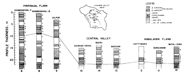
Siltstone. In general it is constituted of dark brown to golden brown loamy silt, locally calcareous and intercalated with thin sandy beds and paleosol horizons. Lithology varies from mud to silt to sand, and has carbonate concretions and organic-matter-enriched palaeosol layers (Singh, 1982; Bhatt, 1989). Its thickness is about ~ 50 m; and in type section is 22 m. Composition varies from highly muddy, silty to sandy.


Lithology Pattern: 
Siltstone


Relationships and Distribution

Lower contact

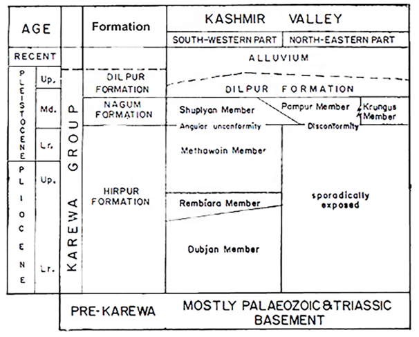
Lower contact in southwest part of basin with Shupiyan Member of Nagum Fm, and in the northeast part of basin with Pampur or Krungus members of Nagum Fm.

[Figure : Classification of Karewa Group]

Upper contact

Upper contact with Karewa terraces and plateaux.

Regional extent

Kashmir-Karewa basin.

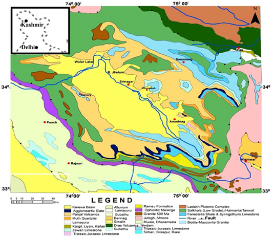
[Figure : Location map of Karewa basin that forms central part of the Kashmir valley basin (modified after Thakur and Rawat, 1992, source Chandra and Ahmad, 2013)]


GeoJSON

{"type":"Feature","geometry":{"type":"MultiPolygon","coordinates":[[[[76.46,33.21],[75.58,34.05],[74.97,34.3],[74.17,34.3],[74.09,33.87],[74.39,33.24],[75.71,32.87],[76.46,33.21]]]]}}

Fossils

No fossil is known from the Dilpur Formation so far.


Age 

Middle to Late Pleistocene. Carbon dating of calcrete indicated an age between 18 to 35 ka. (Kusumgar et al., 1980). Thermoluminescene dating indicates 110,000±10,000 years B.P. age for “loess-paleosol” (Singhvi et al., 1986). Bronger et al., (1987) suggest that the Dilpur Formation ranges in age from Middle to Late Pleistocene in SW, and in NE, it is mainly of Late Pleistocene age. Agarwal et al. (1989) regard commencement of the Karewa sedimentation around 3.8 Ma, coinciding with uplift of the Pir Panjal range. In the Rembiara section they identified five zones having paleomagnetic age exceeding 2.4 Ma, and Zone 6 coincides with lower part of Matuyama polarity chron. In this section the first two zones and half of third represent age between 1.8 to 2.4 Ma. The upper half of Zones 3 and 4 ranges from 1.8 Ma (Olduvai) and 0.7 Ma (Brunhes-Matuyama boundary). In the Romushi section, the succession begins from 2.4 Ma (Matuyama/Gauss boundary). The Zones S1 to 9 are covered by the Brūnhes Chron, hence are younger than 0.7 Ma. These dates have been corroborated by TL and HC dates. The top three paleosols indicate C14 dates of 5, 18 and +24 Ka, the fourth paleosol is older than 31 Ka. The top of triplet, the fourth by TL is dated at >47 ka. Based on these dates Agarwal et al., (1989) suggested that the Lower Karewa sedimentation terminated around 200 ka and the Jhelum River emerged ca 85 ka. The loess deposit has been dated within 200 ka. [See "Depos. Setting" below for Basavaiah et al. (2010) different view that this formation began at 4.2 Ma.]

Age Span: 

    Beginning stage: 
Calabrian

    Fraction up in beginning stage: 
0.0

    Beginning date (Ma): 
1.80

    Ending stage: 
Holocene

    Fraction up in the ending stage: 
0.0

    Ending date (Ma):  
0.01

Depositional setting

Pant et al., (1978) regarded the Dilpur Formation as loess deposits. Singh (1982) suggested that it was likely that after the lake was drained, the sediments were deposited by sluggish streams, mostly in the form of fine-grained flood-plain deposits. And might include some aeolian input.

Basavaiah et al. (2010) recorded 8 normal and 8 reversed polarities ranging between 4.40 and 0.77 Ma, Their anisotropy of magnetic susceptibility data point to a NE-SW flowing river system prior to 4.18 Ma with the Pir Panjal being the provenance. The fluviolacustrine phase according to Basavaiah et al. (2010) prevailed between 4.18 and 0.77 Ma. Relatively strong flow velocities existed towards the NE between 4.18 and 1.07 Ma (upper Gilbert, Gauss and lower and middle Matuyama chron). In upper Matuyama chron (<1.07 Ma) the paleodirection changed to NW, possibly related to emergence of the ancestral Jhelum. The variable temporal sedimentation rates recorded are related to interplay between the climate and pulsating tectonic uplift of the Pir Panjal Range (Basavaiah et al., 2010).


Depositional pattern:  


Additional Information


Compiler:  

Varun Parmar & Rajeev Patnaik; O.N. Bhargava & Birendra Singh